Lindale night lights from space
Night Light of Lindale (Texas) from space (United States) Src. Average luminocity for 10x10km area is 22.304% and for 50x50km: 12.3094%.
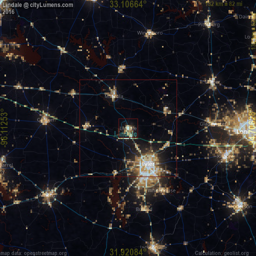
Analysis of Lindale night lights 2016
Square area 10x10 km:
 1.1%
1.1%90-99
1.47%80-89
4.03%70-79
1.28%60-69
2.38%50-59
6.59%40-49
1.83%30-39
8.42%20-29
3.85%10-19
27.29%0-9
41.76%Square area 50x50 km:
1.35%90-99
1.58%80-89
1.77%70-79
1.63%60-69
1.87%50-59
2.19%40-49
1.48%30-39
2.49%20-29
2.66%10-19
6.54%0-9
76.44%Clear (daylight) street map image can be seen on geolist.org.
Map coordinates:
33° 6' 23.9" North, 96° 6' 45.1" West
32° 30' 56.5" North, 95° 24' 33.8" West
31° 55' 15" North, 94° 42' 22.6" West
Some cities around Lindale sort by population:
• Tyler
20.9 km =13 mi,  150°
150°
• Longview
62.7 km =39 mi,  91°
91°
• Kilgore
52.1 km =32.4 mi,  106°
106°
• Athens
54.3 km =33.7 mi,  230°
230°
• Whitehouse
36.5 km =22.7 mi, 151°
• Gladewater
43.8 km =27.2 mi, 86°
• White Oak
51.4 km =31.9 mi, 88°
• Gilmer
49.7 km =30.9 mi,  61°
61°
4706386 (p: 5,692)
Sources (retrieved 2019-11-25):
» Earth at Night: Flat Maps 2012, 2016