New Paltz night lights from space
Night Light of New Paltz (New York) from space (United States) Src. Average luminocity for 10x10km area is 12.0276% and for 50x50km: 13.463%.
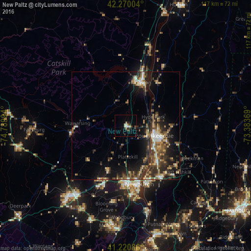
Analysis of New Paltz night lights 2016
Square area 10x10 km:
 1.79%
1.79%90-99
1.14%80-89
2.44%70-79
1.14%60-69
0%50-59
0.32%40-49
2.27%30-39
2.27%20-29
4.71%10-19
0.16%0-9
83.77%Square area 50x50 km:
1.2%90-99
1.3%80-89
1.9%70-79
1.67%60-69
2.04%50-59
1.94%40-49
2.76%30-39
3.2%20-29
5.03%10-19
8.68%0-9
70.27%Clear (daylight) street map image can be seen on geolist.org.
Map coordinates:
42° 16' 12.1" North, 74° 47' 23.8" West
41° 44' 51.3" North, 74° 5' 12.5" West
41° 13' 15.1" North, 73° 23' 1.3" West
Some cities around New Paltz sort by population:
• Poughkeepsie
14.7 km =9.1 mi,  110°
110°
• Kingston
21.3 km =13.2 mi,  20°
20°
• Wawarsing
22.5 km =14 mi,  273°
273°
• Walden
22.4 km =13.9 mi,  202°
202°
• Highland
10.9 km =6.8 mi, 105°
• Wappingers Falls
22.3 km =13.9 mi,  139°
139°
• Marbletown
15.3 km =9.5 mi,  351°
351°
• Fairview
14.1 km =8.8 mi,  100°
100°
5128539 (p: 7,070)
Sources (retrieved 2019-11-25):
» Earth at Night: Flat Maps 2012, 2016