Marbletown night lights from space
Night Light of Marbletown (New York) from space (United States) Src. Average luminocity for 10x10km area is 3.8206% and for 50x50km: 8.1752%.
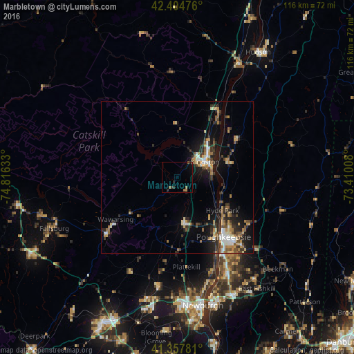
Analysis of Marbletown night lights 2016
Square area 10x10 km:
 0%
0%90-99
0%80-89
0%70-79
0%60-69
2.38%50-59
0.48%40-49
0.16%30-39
1.9%20-29
0.79%10-19
1.75%0-9
92.54%Square area 50x50 km:
0.82%90-99
1.02%80-89
0.97%70-79
1.08%60-69
1.41%50-59
0.81%40-49
1.28%30-39
1.61%20-29
2.6%10-19
5.16%0-9
83.25%Clear (daylight) street map image can be seen on geolist.org.
Map coordinates:
42° 24' 17.1" North, 74° 48' 58.8" West
41° 53' 0.3" North, 74° 6' 47.5" West
41° 21' 28.1" North, 73° 24' 36.3" West
Some cities around Marbletown sort by population:
• Poughkeepsie
25.9 km =16.1 mi,  141°
141°
• Kingston
10.7 km =6.6 mi,  63°
63°
• Wawarsing
24.5 km =15.2 mi,  235°
235°
• New Paltz
15.3 km =9.5 mi,  171°
171°
• Walden
36.4 km =22.6 mi,  189°
189°
• Highland
22.1 km =13.7 mi, 144°
• Wappingers Falls
36 km =22.4 mi,  152°
152°
• Fairview
23.9 km =14.9 mi, 137°
5125973 (p: 5,544)
Sources (retrieved 2019-11-25):
» Earth at Night: Flat Maps 2012, 2016