Warr Acres night lights from space
Night Light of Warr Acres (Oklahoma) from space (United States) Src. Average luminocity for 10x10km area is 92.6868% and for 50x50km: 52.9011%.
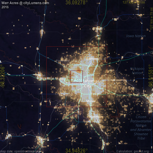
Analysis of Warr Acres night lights 2016
Square area 10x10 km:
 40.11%
90-99
32.78%80-89
11.9%70-79
8.61%60-69
6.41%50-59
0.18%40-49
0%30-39
0%20-29
0%10-19
0%0-9
0%Square area 50x50 km:
13.71%90-99
11.31%80-89
7.17%70-79
7.14%60-69
8.39%50-59
6.96%40-49
5.01%30-39
5.71%20-29
7.1%10-19
8.46%0-9
19.05%Clear (daylight) street map image can be seen on geolist.org.
Map coordinates:
36° 5' 34" North, 98° 19' 19.4" West
35° 31' 21.2" North, 97° 37' 8.1" West
34° 56' 53.7" North, 96° 54' 56.9" West
Some cities around Warr Acres sort by population:
• Oklahoma City
11.1 km =6.9 mi,  123°
123°
• Edmond
19.3 km =12 mi,  41°
41°
• Yukon
13.1 km =8.1 mi,  262°
262°
• Del City
18.4 km =11.4 mi, 119°
• Mustang
18.1 km =11.2 mi,  211°
211°
• Bethany
1.3 km =0.8 mi,  250°
250°
• The Village
7.4 km =4.6 mi,  55°
55°
• Piedmont
17.6 km =10.9 mi,  319°
319°
4554687 (p: 10,431)
Sources (retrieved 2019-11-25):
» Earth at Night: Flat Maps 2012, 2016