Ware night lights from space
Night Light of Ware (Massachusetts) from space (United States) Src. Average luminocity for 10x10km area is 7.1348% and for 50x50km: 9.3255%.
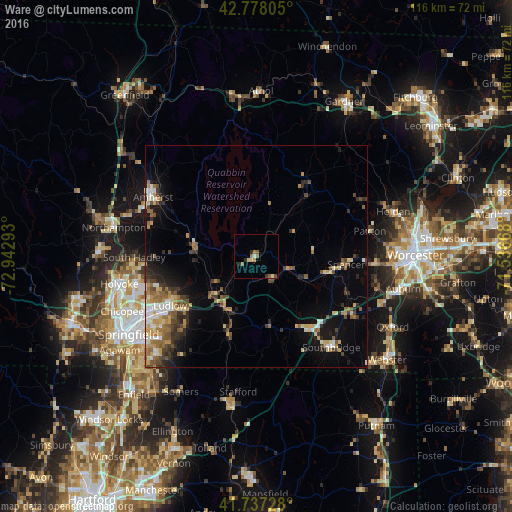
Analysis of Ware night lights 2016
Square area 10x10 km:
 0%
0%90-99
1.21%80-89
1.21%70-79
0.61%60-69
1.82%50-59
1.82%40-49
0.61%30-39
1.06%20-29
1.36%10-19
0%0-9
90.3%Square area 50x50 km:
0.85%90-99
1.2%80-89
1.34%70-79
1.2%60-69
1.6%50-59
1.53%40-49
1.49%30-39
1.44%20-29
2.04%10-19
4.22%0-9
83.09%Clear (daylight) street map image can be seen on geolist.org.
Map coordinates:
42° 46' 41" North, 72° 56' 34.5" West
42° 15' 35.3" North, 72° 14' 23.3" West
41° 44' 14.2" North, 71° 32' 12" West
Some cities around Ware sort by population:
• Amherst
25.8 km =16 mi,  297°
297°
• Ludlow
22.4 km =13.9 mi,  240°
240°
• Amherst Center
26.3 km =16.3 mi, 299°
• Palmer
13.4 km =8.3 mi,  213°
213°
• Charlton
26.2 km =16.3 mi,  121°
121°
• Monson
18.5 km =11.5 mi,  200°
200°
• Spencer
20.4 km =12.7 mi,  94°
94°
• Hampden
26.1 km =16.2 mi, 213°
4954477 (p: 6,170)
Sources (retrieved 2019-11-25):
» Earth at Night: Flat Maps 2012, 2016