Wanaque night lights from space
Night Light of Wanaque (New Jersey) from space (United States) Src. Average luminocity for 10x10km area is 47.0884% and for 50x50km: 45.5227%.
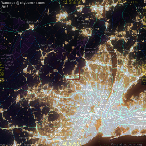
Analysis of Wanaque night lights 2016
Square area 10x10 km:
 4.08%
4.08%90-99
6.46%80-89
5.95%70-79
10.88%60-69
5.78%50-59
14.97%40-49
5.27%30-39
6.29%20-29
18.54%10-19
17.18%0-9
4.59%Square area 50x50 km:
11.09%90-99
9.19%80-89
5.24%70-79
6.98%60-69
10.17%50-59
6.62%40-49
3.96%30-39
3.35%20-29
4.32%10-19
6.65%0-9
32.44%Clear (daylight) street map image can be seen on geolist.org.
Map coordinates:
41° 33' 58.9" North, 74° 59' 49.8" West
41° 2' 17.3" North, 74° 17' 38.5" West
40° 30' 20.4" North, 73° 35' 27.3" West
Some cities around Wanaque sort by population:
• Wyckoff
10.6 km =6.6 mi,  107°
107°
• Oakland
3.7 km =2.3 mi,  138°
138°
• Ringwood
9.3 km =5.8 mi,  25°
25°
• Pompton Lakes
3.7 km =2.3 mi,  175°
175°
• Franklin Lakes
7.8 km =4.8 mi, 107°
• Kinnelon
7.3 km =4.5 mi,  236°
236°
• Bloomingdale
4.9 km =3 mi,  214°
214°
• Butler
5.5 km =3.4 mi,  226°
226°
5106014 (p: 11,848)
Sources (retrieved 2019-11-25):
» Earth at Night: Flat Maps 2012, 2016