Pompton Lakes night lights from space
Night Light of Pompton Lakes (New Jersey) from space (United States) Src. Average luminocity for 10x10km area is 64.6514% and for 50x50km: 50.9328%.
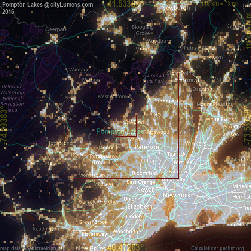
Analysis of Pompton Lakes night lights 2016
Square area 10x10 km:
 7.82%
7.82%90-99
12.24%80-89
7.99%70-79
14.12%60-69
15.65%50-59
19.05%40-49
5.27%30-39
6.46%20-29
9.69%10-19
1.7%0-9
0%Square area 50x50 km:
13.32%90-99
10.78%80-89
5.81%70-79
8.03%60-69
10.65%50-59
6.68%40-49
4.12%30-39
3.34%20-29
4.54%10-19
6.54%0-9
26.19%Clear (daylight) street map image can be seen on geolist.org.
Map coordinates:
41° 32' 1.9" North, 74° 59' 37.8" West
41° 0' 19.4" North, 74° 17' 26.5" West
40° 28' 21.5" North, 73° 35' 15.3" West
Some cities around Pompton Lakes sort by population:
• Wayne
9 km =5.6 mi,  172°
172°
• Oakland
2.4 km =1.5 mi,  68°
68°
• Wanaque
3.7 km =2.3 mi,  355°
355°
• Franklin Lakes
7.2 km =4.5 mi,  79°
79°
• Lincoln Park
9.1 km =5.7 mi,  186°
186°
• Kinnelon
6.4 km =4 mi,  266°
266°
• Bloomingdale
3 km =1.9 mi,  262°
262°
• Butler
4.3 km =2.7 mi, 267°
5102825 (p: 11,202)
Sources (retrieved 2019-11-25):
» Earth at Night: Flat Maps 2012, 2016