Butler night lights from space
Night Light of Butler (New Jersey) from space (United States) Src. Average luminocity for 10x10km area is 50.9303% and for 50x50km: 46.6709%.
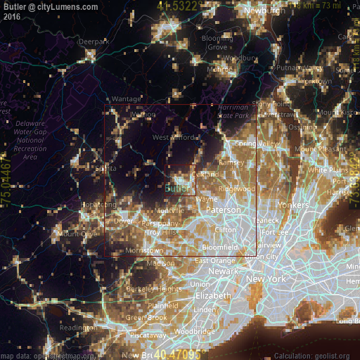
Analysis of Butler night lights 2016
Square area 10x10 km:
 5.1%
5.1%90-99
10.37%80-89
5.95%70-79
11.73%60-69
8.33%50-59
7.14%40-49
8.67%30-39
8.67%20-29
13.44%10-19
17.69%0-9
2.89%Square area 50x50 km:
11.44%90-99
9.02%80-89
5.45%70-79
7.6%60-69
9.44%50-59
6.2%40-49
4.61%30-39
3.82%20-29
5.53%10-19
8.12%0-9
28.77%Clear (daylight) street map image can be seen on geolist.org.
Map coordinates:
41° 31' 55.9" North, 75° 2' 40.8" West
41° 0' 13.4" North, 74° 20' 29.5" West
40° 28' 15.4" North, 73° 38' 18.3" West
Some cities around Butler sort by population:
• Wayne
10.3 km =6.4 mi,  147°
147°
• Oakland
6.6 km =4.1 mi,  80°
80°
• Wanaque
5.5 km =3.4 mi,  46°
46°
• Pompton Lakes
4.3 km =2.7 mi,  87°
87°
• Franklin Lakes
11.5 km =7.1 mi, 82°
• Lincoln Park
9.4 km =5.8 mi,  159°
159°
• Kinnelon
2.2 km =1.4 mi,  264°
264°
• Bloomingdale
1.3 km =0.8 mi,  98°
98°
5096100 (p: 7,701)
Sources (retrieved 2019-11-25):
» Earth at Night: Flat Maps 2012, 2016