Village of Oak Creek (Big Park) night lights from space
Night Light of Village of Oak Creek (Big Park) (Arizona) from space (United States) Src. Average luminocity for 10x10km area is 4.4432% and for 50x50km: 1.8743%.
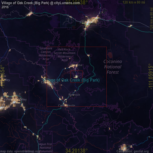
Analysis of Village of Oak Creek (Big Park) night lights 2016
Square area 10x10 km:
 0%
0%90-99
0%80-89
0%70-79
2.75%60-69
0.18%50-59
0.73%40-49
0.18%30-39
1.28%20-29
0.73%10-19
0.92%0-9
93.22%Square area 50x50 km:
0.01%90-99
0.05%80-89
0.04%70-79
0.59%60-69
0.56%50-59
0.34%40-49
0.31%30-39
0.5%20-29
0.3%10-19
0.45%0-9
96.84%Clear (daylight) street map image can be seen on geolist.org.
Map coordinates:
35° 21' 23" North, 112° 27' 55.4" West
34° 46' 51.2" North, 111° 45' 44.2" West
34° 12' 5" North, 111° 3' 32.9" West
Some cities around Village of Oak Creek (Big Park) sort by population:
• Flagstaff
47.5 km =29.5 mi,  12°
12°
• Prescott Valley
54 km =33.6 mi,  249°
249°
• Cottonwood
23.1 km =14.4 mi,  258°
258°
• Verde Village
24.1 km =15 mi, 251°
• West Sedona
10.4 km =6.5 mi,  337°
337°
• Camp Verde
25.6 km =15.9 mi,  199°
199°
• Sedona
9.9 km =6.2 mi,  0°
0°
• Big Park
0.1 km =0.1 mi,  207°
207°
7260892 (p: 6,147)
Sources (retrieved 2019-11-25):
» Earth at Night: Flat Maps 2012, 2016