Prescott Valley night lights from space
Night Light of Prescott Valley (Arizona) from space (United States) Src. Average luminocity for 10x10km area is 38.7133% and for 50x50km: 6.3711%.
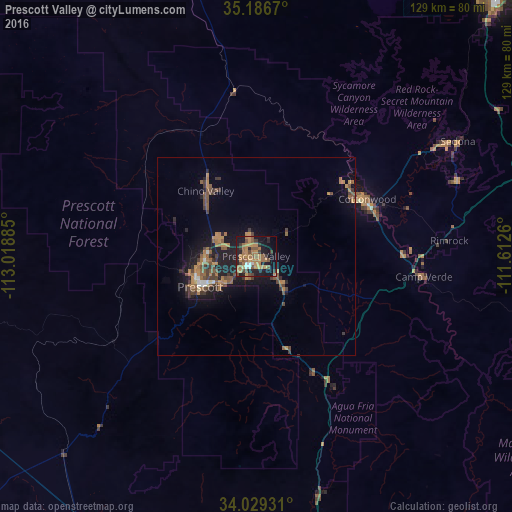

Analysis of Prescott Valley night lights 2016
Square area 10x10 km:
 2.1%
2.1%90-99
1.4%80-89
2.1%70-79
10.31%60-69
17.31%50-59
7.17%40-49
5.42%30-39
5.77%20-29
6.82%10-19
31.12%0-9
10.49%Square area 50x50 km:
0.27%90-99
0.24%80-89
0.19%70-79
1.27%60-69
1.73%50-59
1.59%40-49
1.21%30-39
1.32%20-29
1.22%10-19
5.68%0-9
85.28%Clear (daylight) street map image can be seen on geolist.org.
Map coordinates:
35° 11' 12.1" North, 113° 1' 7.9" West
34° 36' 36.1" North, 112° 18' 56.6" West
34° 1' 45.5" North, 111° 36' 45.4" West
Some cities around Prescott Valley sort by population:
• Cottonwood
31.4 km =19.5 mi,  62°
62°
• Verde Village
30 km =18.6 mi,  68°
68°
• Camp Verde
42.5 km =26.4 mi,  96°
96°
• Chino Valley
20.7 km =12.9 mi,  322°
322°
• Big Park
54 km =33.6 mi, 69°
• Village of Oak Creek (Big Park)
54 km =33.6 mi, 69°
• Williamson
22.4 km =13.9 mi,  293°
293°
• Paulden
33.7 km =20.9 mi,  335°
335°
5309858 (p: 42,197)
Sources (retrieved 2019-11-25):
» Earth at Night: Flat Maps 2012, 2016