Camp Verde night lights from space
Night Light of Camp Verde (Arizona) from space (United States) Src. Average luminocity for 10x10km area is 6.4633% and for 50x50km: 1.7431%.
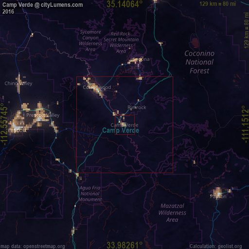
Analysis of Camp Verde night lights 2016
Square area 10x10 km:
 0%
0%90-99
0%80-89
0%70-79
1.75%60-69
1.92%50-59
1.92%40-49
0.87%30-39
1.57%20-29
2.97%10-19
0.7%0-9
88.29%Square area 50x50 km:
0.01%90-99
0.05%80-89
0.04%70-79
0.54%60-69
0.48%50-59
0.4%40-49
0.29%30-39
0.42%20-29
0.27%10-19
0.6%0-9
96.9%Clear (daylight) street map image can be seen on geolist.org.
Map coordinates:
35° 8' 26.3" North, 112° 33' 26.8" West
34° 33' 49.1" North, 111° 51' 15.6" West
33° 58' 57.4" North, 111° 9' 4.3" West
Some cities around Camp Verde sort by population:
• Prescott Valley
42.5 km =26.4 mi,  276°
276°
• Prescott
56.3 km =35 mi,  267°
267°
• Cottonwood
24.2 km =15 mi,  323°
323°
• Verde Village
21.8 km =13.5 mi, 318°
• West Sedona
34.1 km =21.2 mi,  7°
7°
• Sedona
35.1 km =21.8 mi, 14°
• Big Park
25.5 km =15.8 mi,  19°
19°
• Village of Oak Creek (Big Park)
25.6 km =15.9 mi, 19°
5288261 (p: 11,155)
Sources (retrieved 2019-11-25):
» Earth at Night: Flat Maps 2012, 2016