Covedale night lights from space
Night Light of Covedale (Ohio) from space (United States) Src. Average luminocity for 10x10km area is 85.651% and for 50x50km: 53.5591%.
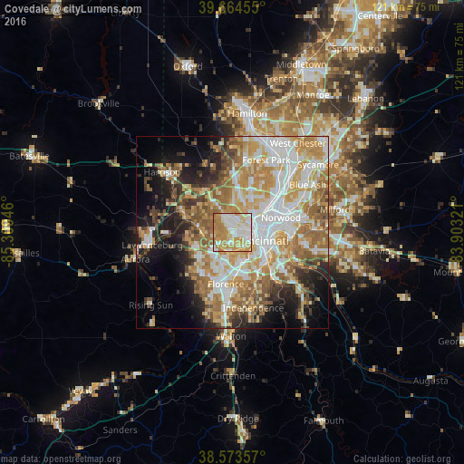
Analysis of Covedale night lights 2016
Square area 10x10 km:
 21.92%
90-99
25.65%80-89
13.31%70-79
22.56%60-69
15.58%50-59
0.97%40-49
0%30-39
0%20-29
0%10-19
0%0-9
0%Square area 50x50 km:
11.53%90-99
11.74%80-89
7.32%70-79
10.16%60-69
9.97%50-59
7.13%40-49
4.01%30-39
3.97%20-29
6.02%10-19
10.14%0-9
18.02%Clear (daylight) street map image can be seen on geolist.org.
Map coordinates:
39° 39' 52.4" North, 85° 18' 34.1" West
39° 7' 16.2" North, 84° 36' 22.8" West
38° 34' 24.9" North, 83° 54' 11.6" West
Some cities around Covedale sort by population:
• Cincinnati
8 km =5 mi,  85°
85°
• Bridgetown
4.4 km =2.7 mi,  323°
323°
• Monfort Heights
7.5 km =4.7 mi,  7°
7°
• Mack
5.6 km =3.5 mi, 317°
• Dent
8.2 km =5.1 mi,  331°
331°
• Cheviot
4 km =2.5 mi,  351°
351°
• Villa Hills
6.5 km =4 mi,  169°
169°
• Delhi Hills
3.2 km =2 mi,  189°
189°
4509506 (p: 6,447)
Sources (retrieved 2019-11-25):
» Earth at Night: Flat Maps 2012, 2016