Upper Saint Clair night lights from space
Night Light of Upper Saint Clair (Pennsylvania) from space (United States) Src. Average luminocity for 10x10km area is 72.6156% and for 50x50km: 48.2663%.
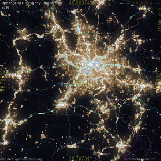
Analysis of Upper Saint Clair night lights 2016
Square area 10x10 km:
 8.33%
8.33%90-99
16.16%80-89
9.69%70-79
13.44%60-69
25.51%50-59
22.11%40-49
3.4%30-39
1.36%20-29
0%10-19
0%0-9
0%Square area 50x50 km:
8.3%90-99
9.21%80-89
5.9%70-79
7.31%60-69
9.96%50-59
9.62%40-49
6.64%30-39
5.57%20-29
8.18%10-19
10.29%0-9
19.01%Clear (daylight) street map image can be seen on geolist.org.
Map coordinates:
40° 52' 11.1" North, 80° 47' 11.5" West
40° 20' 9.2" North, 80° 5' 0.2" West
39° 47' 52.1" North, 79° 22' 49" West
Some cities around Upper Saint Clair sort by population:
• Mount Lebanon
3.6 km =2.2 mi,  53°
53°
• Bethel Park
3.8 km =2.4 mi,  103°
103°
• Whitehall
8.3 km =5.2 mi,  70°
70°
• Dormont
7.9 km =4.9 mi,  32°
32°
• Castle Shannon
6.1 km =3.8 mi,  58°
58°
• Carnegie
8.1 km =5 mi,  0°
0°
• Bridgeville
3.2 km =2 mi,  314°
314°
• Bryn Mawr
3.6 km =2.2 mi,  184°
184°
5216895 (p: 19,229)
Sources (retrieved 2019-11-25):
» Earth at Night: Flat Maps 2012, 2016