Bryn Mawr night lights from space
Night Light of Bryn Mawr (Pennsylvania) from space (United States) Src. Average luminocity for 10x10km area is 65.8622% and for 50x50km: 45.0219%.
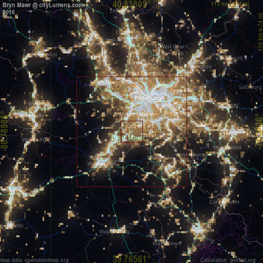
Analysis of Bryn Mawr night lights 2016
Square area 10x10 km:
 4.42%
4.42%90-99
12.07%80-89
5.61%70-79
11.56%60-69
22.79%50-59
29.08%40-49
10.88%30-39
3.06%20-29
0.51%10-19
0%0-9
0%Square area 50x50 km:
7.99%90-99
8.83%80-89
5.42%70-79
6.94%60-69
9.3%50-59
7.89%40-49
5.5%30-39
5.11%20-29
8.04%10-19
10.93%0-9
24.06%Clear (daylight) street map image can be seen on geolist.org.
Map coordinates:
40° 50' 17" North, 80° 47' 23.5" West
40° 18' 14.3" North, 80° 5' 12.2" West
39° 45' 56.2" North, 79° 23' 1" West
Some cities around Bryn Mawr sort by population:
• Mount Lebanon
6.5 km =4 mi,  28°
28°
• Bethel Park
4.8 km =3 mi,  56°
56°
• Baldwin
9.9 km =6.2 mi,  67°
67°
• Upper Saint Clair
3.6 km =2.2 mi,  4°
4°
• South Park Township
7.9 km =4.9 mi,  94°
94°
• Canonsburg
9.7 km =6 mi,  241°
241°
• Castle Shannon
8.7 km =5.4 mi,  38°
38°
• Bridgeville
6.1 km =3.8 mi,  341°
341°
5182063 (p: 5,009)
Sources (retrieved 2019-11-25):
» Earth at Night: Flat Maps 2012, 2016