Trotwood night lights from space
Night Light of Trotwood (Ohio) from space (United States) Src. Average luminocity for 10x10km area is 52.5187% and for 50x50km: 35.1668%.
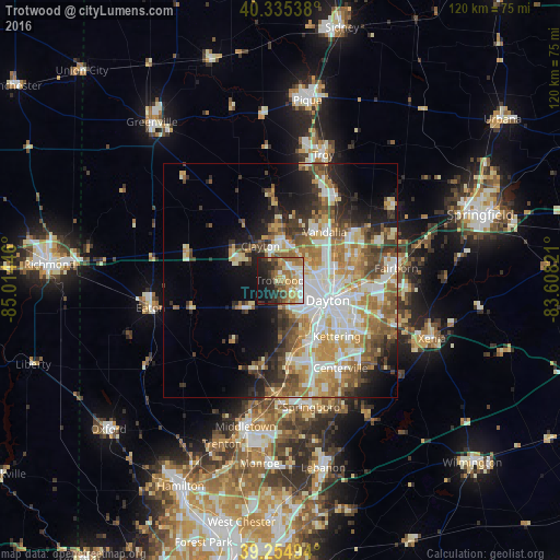

Analysis of Trotwood night lights 2016
Square area 10x10 km:
 6.29%
6.29%90-99
9.35%80-89
8.67%70-79
7.48%60-69
15.82%50-59
7.48%40-49
4.08%30-39
6.97%20-29
13.1%10-19
18.54%0-9
2.21%Square area 50x50 km:
6.9%90-99
7.22%80-89
5%70-79
5.39%60-69
5.81%50-59
4.67%40-49
4.5%30-39
4.1%20-29
5.6%10-19
8.42%0-9
42.38%Clear (daylight) street map image can be seen on geolist.org.
Map coordinates:
40° 20' 7.4" North, 85° 0' 52.1" West
39° 47' 50.2" North, 84° 18' 40.8" West
39° 15' 17.8" North, 83° 36' 29.6" West
Some cities around Trotwood sort by population:
• Dayton
11.1 km =6.9 mi,  112°
112°
• Englewood
9 km =5.6 mi,  5°
5°
• Clayton
8.4 km =5.2 mi,  330°
330°
• Shiloh
7.5 km =4.7 mi,  71°
71°
• Northridge
9.8 km =6.1 mi,  83°
83°
• Union
11.2 km =7 mi,  2°
2°
• Moraine
12.8 km =8 mi,  142°
142°
• Brookville
9.6 km =6 mi,  297°
297°
4526576 (p: 24,096)
Sources (retrieved 2019-11-25):
» Earth at Night: Flat Maps 2012, 2016