Northridge night lights from space
Night Light of Northridge (Ohio) from space (United States) Src. Average luminocity for 10x10km area is 89.2704% and for 50x50km: 38.2778%.
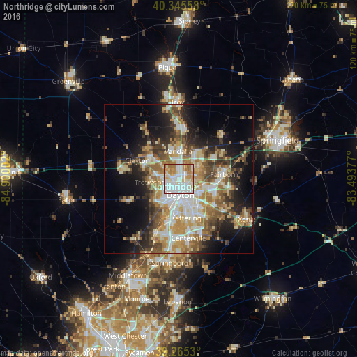
Analysis of Northridge night lights 2016
Square area 10x10 km:
 33.84%
90-99
30.27%80-89
8.67%70-79
12.76%60-69
13.61%50-59
0.85%40-49
0%30-39
0%20-29
0%10-19
0%0-9
0%Square area 50x50 km:
7.04%90-99
7.54%80-89
5.38%70-79
5.63%60-69
6.32%50-59
5.21%40-49
5.03%30-39
5.11%20-29
7.12%10-19
12.06%0-9
33.56%Clear (daylight) street map image can be seen on geolist.org.
Map coordinates:
40° 20' 44.1" North, 84° 54' 0.1" West
39° 48' 27.2" North, 84° 11' 48.8" West
39° 15' 55.1" North, 83° 29' 37.6" West
Some cities around Northridge sort by population:
• Dayton
5.4 km =3.4 mi,  175°
175°
• Huber Heights
7.4 km =4.6 mi,  56°
56°
• Riverside
6.9 km =4.3 mi,  116°
116°
• Trotwood
9.8 km =6.1 mi,  263°
263°
• Vandalia
9.2 km =5.7 mi,  358°
358°
• Shiloh
3 km =1.9 mi,  294°
294°
• Oakwood
9.3 km =5.8 mi,  167°
167°
• Moraine
11.4 km =7.1 mi,  189°
189°
4519951 (p: 8,487)
Sources (retrieved 2019-11-25):
» Earth at Night: Flat Maps 2012, 2016