Tipp City night lights from space
Night Light of Tipp City (Ohio) from space (United States) Src. Average luminocity for 10x10km area is 40.8622% and for 50x50km: 27.7361%.
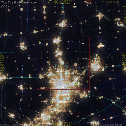
Analysis of Tipp City night lights 2016
Square area 10x10 km:
 5.44%
5.44%90-99
5.95%80-89
3.57%70-79
5.27%60-69
6.46%50-59
5.44%40-49
9.18%30-39
10.03%20-29
21.09%10-19
17.01%0-9
10.54%Square area 50x50 km:
5.23%90-99
5.43%80-89
3.48%70-79
3.38%60-69
4.44%50-59
3.39%40-49
3.42%30-39
4.23%20-29
6.33%10-19
11.89%0-9
48.8%Clear (daylight) street map image can be seen on geolist.org.
Map coordinates:
40° 29' 42.8" North, 84° 52' 31" West
39° 57' 30.2" North, 84° 10' 19.8" West
39° 25' 2.4" North, 83° 28' 8.5" West
Some cities around Tipp City sort by population:
• Huber Heights
13.4 km =8.3 mi,  162°
162°
• Troy
9.4 km =5.8 mi,  343°
343°
• Vandalia
7.9 km =4.9 mi,  196°
196°
• Englewood
14.3 km =8.9 mi,  230°
230°
• Shiloh
16.3 km =10.1 mi, 197°
• Northridge
16.9 km =10.5 mi,  187°
187°
• Union
13.3 km =8.3 mi,  239°
239°
• New Carlisle
12.7 km =7.9 mi,  101°
101°
4526365 (p: 9,899)
Sources (retrieved 2019-11-25):
» Earth at Night: Flat Maps 2012, 2016