Tiburon night lights from space
Night Light of Tiburon (California) from space (United States) Src. Average luminocity for 10x10km area is 24.6039% and for 50x50km: 30.9214%.
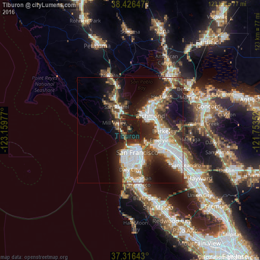
Analysis of Tiburon night lights 2016
Square area 10x10 km:
 0.65%
0.65%90-99
0.65%80-89
1.3%70-79
1.46%60-69
2.11%50-59
5.52%40-49
8.28%30-39
3.73%20-29
15.91%10-19
53.9%0-9
6.49%Square area 50x50 km:
8.06%90-99
6.27%80-89
1.78%70-79
3.4%60-69
3.49%50-59
3.85%40-49
4.75%30-39
4.56%20-29
9.07%10-19
13.34%0-9
41.44%Clear (daylight) street map image can be seen on geolist.org.
Map coordinates:
38° 25' 35.3" North, 123° 9' 35.2" West
37° 52' 24.7" North, 122° 27' 23.9" West
37° 18' 59.1" North, 121° 45' 12.7" West
Some cities around Tiburon sort by population:
• Chinatown
9.5 km =5.9 mi,  153°
153°
• Mill Valley
8.6 km =5.3 mi,  294°
294°
• Larkspur
9.6 km =6 mi,  314°
314°
• Tamalpais-Homestead Valley
7 km =4.3 mi,  274°
274°
• Corte Madera
8.5 km =5.3 mi, 312°
• Sausalito
3 km =1.9 mi,  237°
237°
• Tamalpais Valley
7.9 km =4.9 mi, 274°
• Strawberry
5.3 km =3.3 mi,  299°
299°
5402535 (p: 9,214)
Sources (retrieved 2019-11-25):
» Earth at Night: Flat Maps 2012, 2016