Thibodaux night lights from space
Night Light of Thibodaux (Louisiana) from space (United States) Src. Average luminocity for 10x10km area is 57.881% and for 50x50km: 19.3987%.
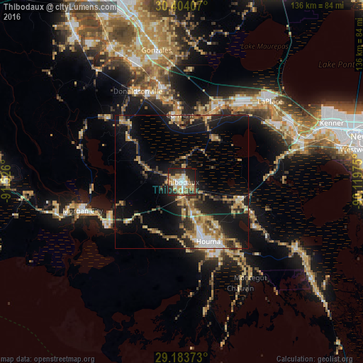
Analysis of Thibodaux night lights 2016
Square area 10x10 km:
 9.52%
9.52%90-99
11.71%80-89
10.32%70-79
12.3%60-69
11.11%50-59
2.18%40-49
3.97%30-39
7.34%20-29
21.43%10-19
10.12%0-9
0%Square area 50x50 km:
1.77%90-99
1.94%80-89
3.57%70-79
2.89%60-69
3.77%50-59
1.67%40-49
2.4%30-39
3.63%20-29
5.32%10-19
15.31%0-9
57.73%Clear (daylight) street map image can be seen on geolist.org.
Map coordinates:
30° 24' 14.7" North, 91° 31' 33.6" West
29° 47' 44.7" North, 90° 49' 22.3" West
29° 11' 1.4" North, 90° 7' 11.1" West
Some cities around Thibodaux sort by population:
• Houma
24.4 km =15.2 mi,  155°
155°
• Bayou Cane
20.3 km =12.6 mi, 160°
• Morgan City
38.6 km =24 mi,  253°
253°
• Raceland
22.9 km =14.2 mi,  109°
109°
• Donaldsonville
37.8 km =23.5 mi,  334°
334°
• Schriever
6.1 km =3.8 mi,  168°
168°
• Gray
11.5 km =7.1 mi, 162°
• Chackbay
10.1 km =6.3 mi,  14°
14°
4343429 (p: 14,584)
Sources (retrieved 2019-11-25):
» Earth at Night: Flat Maps 2012, 2016