Chackbay night lights from space
Night Light of Chackbay (Louisiana) from space (United States) Src. Average luminocity for 10x10km area is 12.7778% and for 50x50km: 21.7917%.
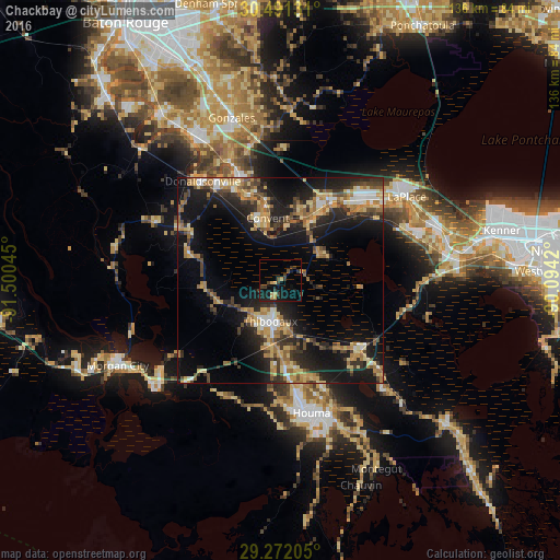
Analysis of Chackbay night lights 2016
Square area 10x10 km:
 0%
0%90-99
0%80-89
1.59%70-79
3.77%60-69
0.2%50-59
0.4%40-49
2.58%30-39
6.35%20-29
1.59%10-19
15.67%0-9
67.86%Square area 50x50 km:
1.56%90-99
1.94%80-89
4.01%70-79
3.42%60-69
4.68%50-59
2.14%40-49
3.09%30-39
4.34%20-29
6.81%10-19
17.38%0-9
50.64%Clear (daylight) street map image can be seen on geolist.org.
Map coordinates:
30° 29' 28.7" North, 91° 30' 1.6" West
29° 53' 0.7" North, 90° 47' 50.4" West
29° 16' 19.4" North, 90° 5' 39.1" West
Some cities around Chackbay sort by population:
• Houma
32.9 km =20.4 mi,  166°
166°
• Bayou Cane
29.2 km =18.1 mi, 171°
• Thibodaux
10.1 km =6.3 mi,  194°
194°
• Raceland
25.8 km =16 mi,  132°
132°
• Reserve
30.3 km =18.8 mi,  51°
51°
• Donaldsonville
30.7 km =19.1 mi,  321°
321°
• Schriever
15.8 km =9.8 mi,  184°
184°
• Gray
20.7 km =12.9 mi, 177°
4319507 (p: 5,177)
Sources (retrieved 2019-11-25):
» Earth at Night: Flat Maps 2012, 2016