Morgan City night lights from space
Night Light of Morgan City (Louisiana) from space (United States) Src. Average luminocity for 10x10km area is 43.7877% and for 50x50km: 7.3079%.
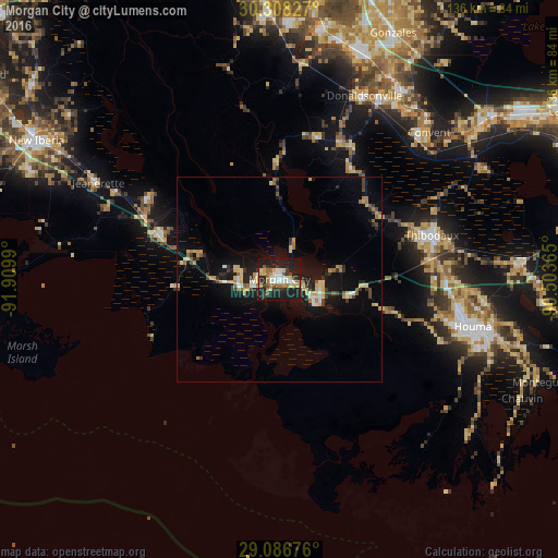
Analysis of Morgan City night lights 2016
Square area 10x10 km:
 6.55%
6.55%90-99
7.94%80-89
7.94%70-79
3.77%60-69
8.53%50-59
3.17%40-49
1.79%30-39
7.54%20-29
15.87%10-19
36.71%0-9
0.2%Square area 50x50 km:
0.56%90-99
0.74%80-89
1.42%70-79
0.95%60-69
1.14%50-59
0.51%40-49
0.66%30-39
1.18%20-29
1.73%10-19
7.09%0-9
84.01%Clear (daylight) street map image can be seen on geolist.org.
Map coordinates:
30° 18' 29.8" North, 91° 54' 35.6" West
29° 41' 57.7" North, 91° 12' 24.4" West
29° 5' 12.3" North, 90° 30' 13.1" West
Some cities around Morgan City sort by population:
• Houma
48.5 km =30.1 mi,  103°
103°
• Bayou Cane
44.8 km =27.8 mi, 100°
• Thibodaux
38.6 km =24 mi,  73°
73°
• Franklin
30.4 km =18.9 mi,  290°
290°
• Schriever
38.6 km =24 mi,  82°
82°
• Patterson
9.2 km =5.7 mi,  265°
265°
• Gray
40.6 km =25.2 mi,  90°
90°
• Chackbay
44.5 km =27.7 mi,  62°
62°
4333811 (p: 11,835)
Sources (retrieved 2019-11-25):
» Earth at Night: Flat Maps 2012, 2016