Donaldsonville night lights from space
Night Light of Donaldsonville (Louisiana) from space (United States) Src. Average luminocity for 10x10km area is 44.6856% and for 50x50km: 29.9754%.
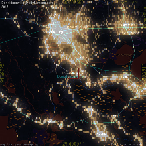
Analysis of Donaldsonville night lights 2016
Square area 10x10 km:
 4.55%
4.55%90-99
3.79%80-89
6.82%70-79
5.68%60-69
9.66%50-59
4.92%40-49
12.5%30-39
15.34%20-29
12.12%10-19
24.24%0-9
0.38%Square area 50x50 km:
2.44%90-99
2.43%80-89
6.26%70-79
5.44%60-69
6.88%50-59
4.37%40-49
7.18%30-39
4.85%20-29
5.71%10-19
12.23%0-9
42.22%Clear (daylight) street map image can be seen on geolist.org.
Map coordinates:
30° 42' 27.2" North, 91° 41' 50.1" West
30° 6' 4.1" North, 90° 59' 38.8" West
29° 29' 27.5" North, 90° 17' 27.6" West
Some cities around Donaldsonville sort by population:
• Prairieville
22.5 km =14 mi,  5°
5°
• Gonzales
16.9 km =10.5 mi,  24°
24°
• Gardere
30.6 km =19 mi,  332°
332°
• Oak Hills Place
30.1 km =18.7 mi,  342°
342°
• Village Saint George
29.9 km =18.6 mi,  346°
346°
• Plaquemine
31.3 km =19.4 mi,  312°
312°
• Saint Gabriel
20.1 km =12.5 mi, 329°
• Chackbay
30.7 km =19.1 mi,  141°
141°
4322811 (p: 7,792)
Sources (retrieved 2019-11-25):
» Earth at Night: Flat Maps 2012, 2016