Elburn night lights from space
Night Light of Elburn (Illinois) from space (United States) Src. Average luminocity for 10x10km area is 19.6714% and for 50x50km: 39.2138%.
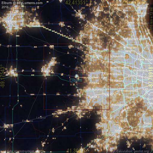
Analysis of Elburn night lights 2016
Square area 10x10 km:
 1.11%
1.11%90-99
1.43%80-89
2.22%70-79
0.95%60-69
2.06%50-59
2.86%40-49
4.44%30-39
5.87%20-29
8.73%10-19
28.73%0-9
41.59%Square area 50x50 km:
6.99%90-99
7.73%80-89
6.57%70-79
6.55%60-69
8.35%50-59
5.98%40-49
3.6%30-39
3.07%20-29
4.81%10-19
7.65%0-9
38.7%Clear (daylight) street map image can be seen on geolist.org.
Map coordinates:
42° 24' 48.6" North, 89° 10' 31.5" West
41° 53' 32.1" North, 88° 28' 20.3" West
41° 22' 0.1" North, 87° 46' 9" West
Some cities around Elburn sort by population:
• Saint Charles
13.8 km =8.6 mi,  79°
79°
• Batavia
14 km =8.7 mi,  109°
109°
• Wasco
7.6 km =4.7 mi,  47°
47°
• South Elgin
18.7 km =11.6 mi, 52°
• Geneva
13.8 km =8.6 mi,  92°
92°
• North Aurora
15.4 km =9.6 mi,  128°
128°
• Village of Campton Hills
7.9 km =4.9 mi, 51°
• Sugar Grove
14.7 km =9.1 mi,  170°
170°
4890835 (p: 5,748)
Sources (retrieved 2019-11-25):
» Earth at Night: Flat Maps 2012, 2016