Sudley night lights from space
Night Light of Sudley (Virginia) from space (United States) Src. Average luminocity for 10x10km area is 78.9847% and for 50x50km: 44.8988%.
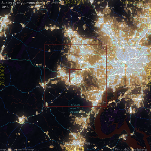
Analysis of Sudley night lights 2016
Square area 10x10 km:
 22.79%
90-99
23.98%80-89
9.52%70-79
12.07%60-69
15.14%50-59
2.38%40-49
2.04%30-39
10.2%20-29
1.87%10-19
0%0-9
0%Square area 50x50 km:
7.88%90-99
8.97%80-89
5.55%70-79
8.96%60-69
9.92%50-59
6.66%40-49
4.67%30-39
5.49%20-29
6.32%10-19
6.9%0-9
28.67%Clear (daylight) street map image can be seen on geolist.org.
Map coordinates:
39° 20' 19.7" North, 78° 12' 2.2" West
38° 47' 34.4" North, 77° 29' 51" West
38° 14' 33.9" North, 76° 47' 39.7" West
Some cities around Sudley sort by population:
• Centreville
8 km =5 mi,  48°
48°
• Manassas
5 km =3.1 mi,  157°
157°
• Linton Hall
7.7 km =4.8 mi,  241°
241°
• Buckhall
8.9 km =5.5 mi,  139°
139°
• Manassas Park
2.6 km =1.6 mi,  112°
112°
• Bull Run
2.2 km =1.4 mi, 242°
• West Gate
1.1 km =0.7 mi,  180°
180°
• Yorkshire
4.3 km =2.7 mi,  89°
89°
4788145 (p: 16,203)
Sources (retrieved 2019-11-25):
» Earth at Night: Flat Maps 2012, 2016