Storrs night lights from space
Night Light of Storrs (Connecticut) from space (United States) Src. Average luminocity for 10x10km area is 18.9515% and for 50x50km: 10.3773%.
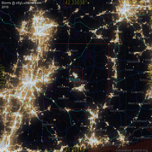
Analysis of Storrs night lights 2016
Square area 10x10 km:
 1.52%
1.52%90-99
2.42%80-89
3.94%70-79
1.82%60-69
2.42%50-59
1.36%40-49
1.36%30-39
1.67%20-29
3.33%10-19
28.18%0-9
51.97%Square area 50x50 km:
0.68%90-99
1.09%80-89
1.7%70-79
1.14%60-69
1.65%50-59
1.73%40-49
1.59%30-39
1.53%20-29
3.33%10-19
7.83%0-9
77.73%Clear (daylight) street map image can be seen on geolist.org.
Map coordinates:
42° 19' 49.4" North, 72° 57' 9.5" West
41° 48' 30.3" North, 72° 14' 58.3" West
41° 16' 55.9" North, 71° 32' 47" West
Some cities around Storrs sort by population:
• Mansfield City
4.9 km =3 mi,  164°
164°
• Windham
14.3 km =8.9 mi,  147°
147°
• Willimantic
11.4 km =7.1 mi, 162°
• Tolland
12.1 km =7.5 mi,  305°
305°
• Ellington
21.1 km =13.1 mi,  300°
300°
• Stafford
19.9 km =12.4 mi,  350°
350°
• Hebron
19.3 km =12 mi,  209°
209°
• Rockville
17.8 km =11.1 mi,  291°
291°
4843786 (p: 15,344)
Sources (retrieved 2019-11-25):
» Earth at Night: Flat Maps 2012, 2016