Statesboro night lights from space
Night Light of Statesboro (Georgia) from space (United States) Src. Average luminocity for 10x10km area is 65.141% and for 50x50km: 6.2728%.
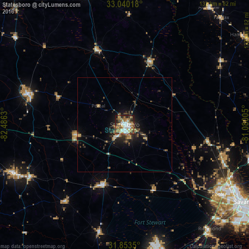

Analysis of Statesboro night lights 2016
Square area 10x10 km:
 13.74%
90-99
13.19%80-89
7.14%70-79
12.82%60-69
15.93%50-59
5.13%40-49
8.79%30-39
7.88%20-29
9.89%10-19
5.49%0-9
0%Square area 50x50 km:
0.68%90-99
0.66%80-89
0.69%70-79
0.96%60-69
1.08%50-59
0.74%40-49
1.01%30-39
1.34%20-29
2.18%10-19
3.99%0-9
86.66%Clear (daylight) street map image can be seen on geolist.org.
Map coordinates:
33° 2' 24.6" North, 82° 29' 10.7" West
32° 26' 55.6" North, 81° 46' 59.4" West
31° 51' 12.6" North, 81° 4' 48.2" West
Some cities around Statesboro sort by population:
• Hinesville
69.2 km =43 mi,  165°
165°
• Pooler
62.6 km =38.9 mi,  126°
126°
• Vidalia
64.6 km =40.1 mi,  246°
246°
• Rincon
54.2 km =33.7 mi,  108°
108°
• Port Wentworth
67.1 km =41.7 mi,  119°
119°
• Swainsboro
54.2 km =33.7 mi,  287°
287°
• Hardeeville
68.4 km =42.5 mi, 105°
• Glennville
58.6 km =36.4 mi,  193°
193°
4224413 (p: 30,721)
Sources (retrieved 2019-11-25):
» Earth at Night: Flat Maps 2012, 2016