Springfield night lights from space
Night Light of Springfield (Florida) from space (United States) Src. Average luminocity for 10x10km area is 65.7509% and for 50x50km: 14.1688%.
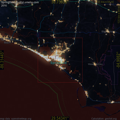
Analysis of Springfield night lights 2016
Square area 10x10 km:
 15.64%
90-99
17.82%80-89
8.73%70-79
10.18%60-69
8.36%50-59
3.64%40-49
5.09%30-39
11.64%20-29
16.18%10-19
2.73%0-9
0%Square area 50x50 km:
2.09%90-99
2.35%80-89
1.01%70-79
2.71%60-69
2.48%50-59
0.79%40-49
1.96%30-39
2.54%20-29
4.99%10-19
8.29%0-9
70.79%Clear (daylight) street map image can be seen on geolist.org.
Map coordinates:
30° 45' 33.7" North, 86° 18' 52" West
30° 9' 11.7" North, 85° 36' 40.8" West
29° 32' 36.3" North, 84° 54' 29.5" West
Some cities around Springfield sort by population:
• Panama City
4.7 km =2.9 mi,  278°
278°
• Lynn Haven
10.9 km =6.8 mi,  340°
340°
• Callaway
4 km =2.5 mi,  90°
90°
• Upper Grand Lagoon
12.5 km =7.8 mi, 275°
• Panama City Beach
18.8 km =11.7 mi, 277°
• Marianna
78.3 km =48.7 mi,  28°
28°
• Miramar Beach
75.9 km =47.2 mi,  288°
288°
• DeFuniak Springs
79.5 km =49.4 mi,  322°
322°
4173892 (p: 9,442)
Sources (retrieved 2019-11-25):
» Earth at Night: Flat Maps 2012, 2016