Miramar Beach night lights from space
Night Light of Miramar Beach (Florida) from space (United States) Src. Average luminocity for 10x10km area is 31.9579% and for 50x50km: 12.1021%.
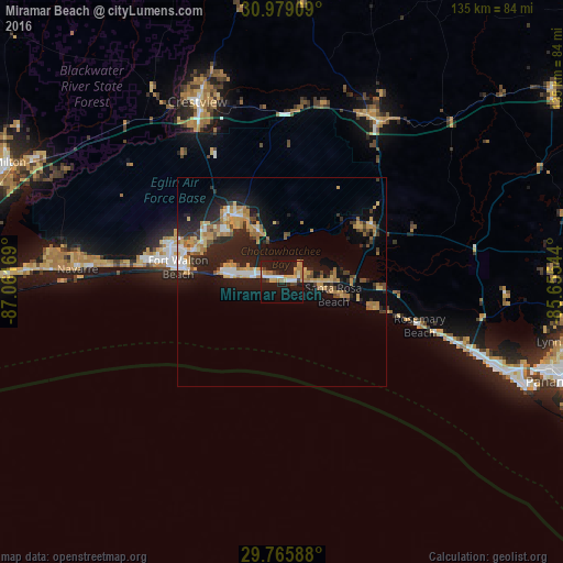
Analysis of Miramar Beach night lights 2016
Square area 10x10 km:
 4.4%
4.4%90-99
3.66%80-89
5.49%70-79
5.13%60-69
7.69%50-59
0%40-49
2.2%30-39
2.38%20-29
4.4%10-19
45.6%0-9
19.05%Square area 50x50 km:
1.28%90-99
0.97%80-89
1.97%70-79
2.25%60-69
2.2%50-59
0.77%40-49
1.31%30-39
1.51%20-29
4.06%10-19
11.72%0-9
71.96%Clear (daylight) street map image can be seen on geolist.org.
Map coordinates:
30° 58' 44.7" North, 87° 3' 42.1" West
30° 22' 27.7" North, 86° 21' 30.8" West
29° 45' 57.2" North, 85° 39' 19.6" West
Some cities around Miramar Beach sort by population:
• Wright
28.3 km =17.6 mi,  288°
288°
• Fort Walton Beach
25.3 km =15.7 mi,  281°
281°
• Niceville
19.8 km =12.3 mi,  323°
323°
• Destin
13.3 km =8.3 mi, 279°
• Lake Lorraine
21.2 km =13.2 mi, 290°
• Eglin Village
19.9 km =12.4 mi,  299°
299°
• Ocean City
25.6 km =15.9 mi, 286°
• Valparaiso
20.3 km =12.6 mi, 317°
4164602 (p: 6,146)
Sources (retrieved 2019-11-25):
» Earth at Night: Flat Maps 2012, 2016