South Hadley night lights from space
Night Light of South Hadley (Massachusetts) from space (United States) Src. Average luminocity for 10x10km area is 32.9803% and for 50x50km: 20.2299%.
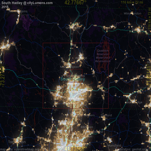
Analysis of South Hadley night lights 2016
Square area 10x10 km:
 1.21%
1.21%90-99
2.27%80-89
7.12%70-79
3.48%60-69
4.09%50-59
6.36%40-49
4.7%30-39
12.12%20-29
14.24%10-19
29.85%0-9
14.55%Square area 50x50 km:
3.01%90-99
3.39%80-89
3%70-79
2.95%60-69
3.09%50-59
2.87%40-49
2.9%30-39
3.25%20-29
4.2%10-19
9.49%0-9
61.84%Clear (daylight) street map image can be seen on geolist.org.
Map coordinates:
42° 46' 36" North, 73° 16' 39.6" West
42° 15' 30.3" North, 72° 34' 28.3" West
41° 44' 9.2" North, 71° 52' 17.1" West
Some cities around South Hadley sort by population:
• Chicopee
12.5 km =7.8 mi,  192°
192°
• North Chicopee
8.6 km =5.3 mi, 193°
• Holyoke
6.9 km =4.3 mi,  209°
209°
• Amherst
12.9 km =8 mi,  20°
20°
• Northampton
9.2 km =5.7 mi,  323°
323°
• Ludlow
13.6 km =8.5 mi,  143°
143°
• Amherst Center
13.8 km =8.6 mi, 19°
• Easthampton
7.8 km =4.8 mi,  276°
276°
4951397 (p: 17,652)
Sources (retrieved 2019-11-25):
» Earth at Night: Flat Maps 2012, 2016