Easthampton night lights from space
Night Light of Easthampton (Massachusetts) from space (United States) Src. Average luminocity for 10x10km area is 25.0833% and for 50x50km: 19.3484%.
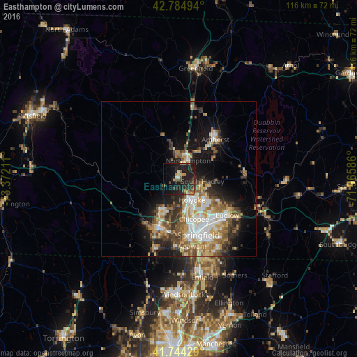
Analysis of Easthampton night lights 2016
Square area 10x10 km:
 0.91%
0.91%90-99
0.91%80-89
4.09%70-79
3.03%60-69
1.82%50-59
3.48%40-49
4.39%30-39
6.21%20-29
16.52%10-19
35.76%0-9
22.88%Square area 50x50 km:
3.01%90-99
3.35%80-89
2.78%70-79
2.83%60-69
2.98%50-59
2.73%40-49
2.68%30-39
3.05%20-29
3.91%10-19
9.23%0-9
63.44%Clear (daylight) street map image can be seen on geolist.org.
Map coordinates:
42° 47' 5.8" North, 73° 22' 19.6" West
42° 16' 0.3" North, 72° 40' 8.3" West
41° 44' 39.4" North, 71° 57' 57.1" West
Some cities around Easthampton sort by population:
• Chicopee
14.1 km =8.8 mi,  159°
159°
• North Chicopee
10.9 km =6.8 mi,  148°
148°
• Westfield
17.1 km =10.6 mi,  202°
202°
• Holyoke
8.2 km =5.1 mi, 147°
• Amherst
16.7 km =10.4 mi,  47°
47°
• Northampton
6.9 km =4.3 mi,  19°
19°
• South Hadley
7.8 km =4.8 mi,  96°
96°
• Southampton
6.5 km =4 mi,  230°
230°
4935582 (p: 16,611)
Sources (retrieved 2019-11-25):
» Earth at Night: Flat Maps 2012, 2016