Somerville night lights from space
Night Light of Somerville (New Jersey) from space (United States) Src. Average luminocity for 10x10km area is 70.6234% and for 50x50km: 44.5523%.
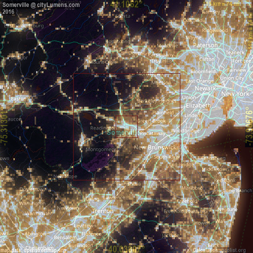
Analysis of Somerville night lights 2016
Square area 10x10 km:
 12.99%
90-99
15.58%80-89
6.98%70-79
12.18%60-69
16.23%50-59
20.29%40-49
7.79%30-39
7.14%20-29
0.81%10-19
0%0-9
0%Square area 50x50 km:
6.73%90-99
7.98%80-89
6.1%70-79
8.41%60-69
8.85%50-59
8.22%40-49
6.27%30-39
5.62%20-29
6.23%10-19
9.74%0-9
25.84%Clear (daylight) street map image can be seen on geolist.org.
Map coordinates:
41° 6' 22.3" North, 75° 18' 46.8" West
40° 34' 27.4" North, 74° 36' 35.6" West
40° 2' 17.1" North, 73° 54' 24.3" West
Some cities around Somerville sort by population:
• Bridgewater
4.4 km =2.7 mi,  312°
312°
• Bradley Gardens
4 km =2.5 mi,  251°
251°
• Martinsville
5.2 km =3.2 mi,  55°
55°
• Bound Brook
6.1 km =3.8 mi,  96°
96°
• Manville
4.2 km =2.6 mi,  153°
153°
• Raritan
2 km =1.2 mi, 254°
• Green Knoll
2.9 km =1.8 mi,  356°
356°
• Finderne
3 km =1.9 mi,  114°
114°
5104774 (p: 12,202)
Sources (retrieved 2019-11-25):
» Earth at Night: Flat Maps 2012, 2016