Bound Brook night lights from space
Night Light of Bound Brook (New Jersey) from space (United States) Src. Average luminocity for 10x10km area is 77.4513% and for 50x50km: 53.095%.
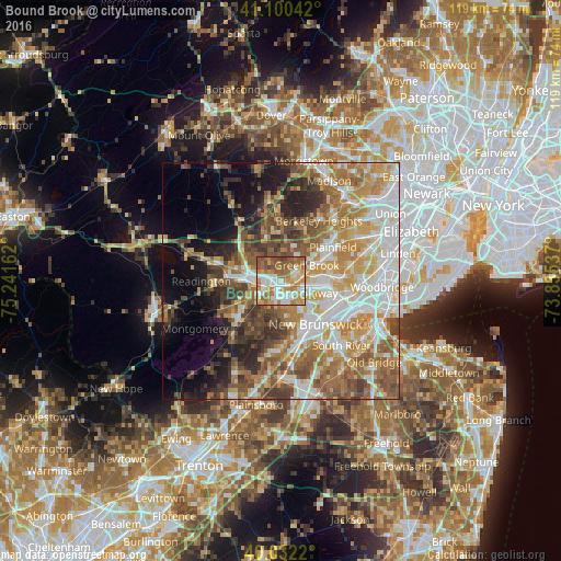
Analysis of Bound Brook night lights 2016
Square area 10x10 km:
 16.07%
90-99
21.1%80-89
5.19%70-79
18.99%60-69
19.32%50-59
15.58%40-49
3.08%30-39
0.65%20-29
0%10-19
0%0-9
0%Square area 50x50 km:
10.5%90-99
10.9%80-89
7.26%70-79
9.11%60-69
9.66%50-59
9.13%40-49
6.5%30-39
5.44%20-29
5.78%10-19
7.61%0-9
18.11%Clear (daylight) street map image can be seen on geolist.org.
Map coordinates:
41° 6' 1.5" North, 75° 14' 29.8" West
40° 34' 6.4" North, 74° 32' 18.6" West
40° 1' 55.9" North, 73° 50' 7.3" West
Some cities around Bound Brook sort by population:
• Warren Township
4.7 km =2.9 mi,  21°
21°
• Middlesex
3.9 km =2.4 mi,  83°
83°
• Somerville
6.1 km =3.8 mi,  276°
276°
• Martinsville
4 km =2.5 mi,  334°
334°
• Manville
5.2 km =3.2 mi,  233°
233°
• Dunellen
6.1 km =3.8 mi,  67°
67°
• Green Knoll
7.1 km =4.4 mi,  299°
299°
• Finderne
3.4 km =2.1 mi,  259°
259°
5095860 (p: 10,497)
Sources (retrieved 2019-11-25):
» Earth at Night: Flat Maps 2012, 2016