Sheridan night lights from space
Night Light of Sheridan (Oregon) from space (United States) Src. Average luminocity for 10x10km area is 4.6742% and for 50x50km: 2.6584%.
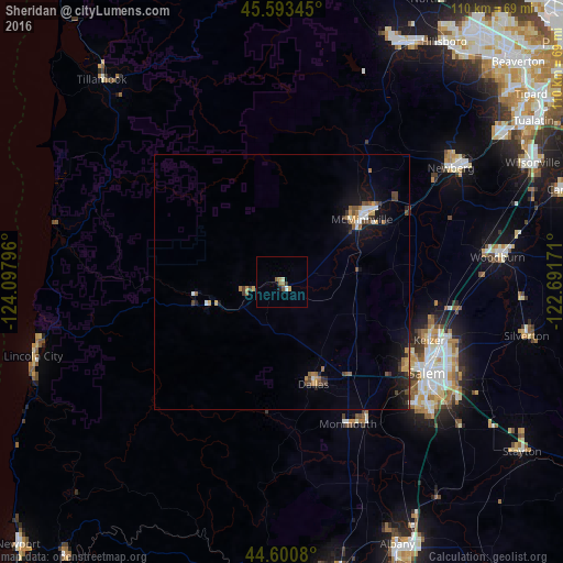
Analysis of Sheridan night lights 2016
Square area 10x10 km:
 0.45%
0.45%90-99
0.76%80-89
0.3%70-79
0.91%60-69
0.61%50-59
1.67%40-49
0.15%30-39
0.61%20-29
0.3%10-19
0.3%0-9
93.94%Square area 50x50 km:
0.25%90-99
0.27%80-89
0.14%70-79
0.43%60-69
0.44%50-59
0.41%40-49
0.49%30-39
0.38%20-29
0.47%10-19
2.21%0-9
94.52%Clear (daylight) street map image can be seen on geolist.org.
Map coordinates:
45° 35' 36.4" North, 124° 5' 52.7" West
45° 5' 57.4" North, 123° 23' 41.4" West
44° 36' 2.9" North, 122° 41' 30.2" West
Some cities around Sheridan sort by population:
• Salem
33.2 km =20.6 mi,  121°
121°
• Keizer
31.4 km =19.5 mi,  112°
112°
• McMinnville
19.7 km =12.2 mi,  51°
51°
• Hayesville
34.7 km =21.6 mi, 111°
• Four Corners
37.5 km =23.3 mi, 120°
• Dallas
20.9 km =13 mi,  163°
163°
• Monmouth
30.6 km =19 mi, 155°
• Independence
32.1 km =19.9 mi,  149°
149°
5751600 (p: 6,094)
Sources (retrieved 2019-11-25):
» Earth at Night: Flat Maps 2012, 2016