Shelbyville night lights from space
Night Light of Shelbyville (Kentucky) from space (United States) Src. Average luminocity for 10x10km area is 38.2585% and for 50x50km: 10.4302%.
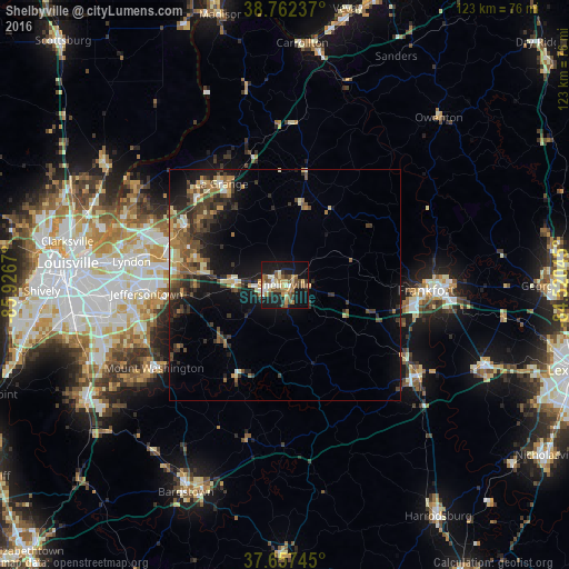
Analysis of Shelbyville night lights 2016
Square area 10x10 km:
 2.89%
2.89%90-99
6.8%80-89
7.31%70-79
3.57%60-69
6.8%50-59
7.48%40-49
6.63%30-39
3.23%20-29
6.8%10-19
36.9%0-9
11.56%Square area 50x50 km:
0.47%90-99
1.18%80-89
1.41%70-79
1.25%60-69
1.56%50-59
1.86%40-49
2.5%30-39
2.51%20-29
2.84%10-19
8.17%0-9
76.26%Clear (daylight) street map image can be seen on geolist.org.
Map coordinates:
38° 45' 44.5" North, 85° 55' 36.1" West
38° 12' 43.2" North, 85° 13' 24.9" West
37° 39' 26.8" North, 84° 31' 13.6" West
Some cities around Shelbyville sort by population:
• Frankfort
30.6 km =19 mi,  92°
92°
• Jeffersontown
29.8 km =18.5 mi,  266°
266°
• Fern Creek
32.4 km =20.1 mi,  259°
259°
• Mount Washington
33.4 km =20.8 mi,  237°
237°
• La Grange
25.6 km =15.9 mi,  328°
328°
• Middletown
27.8 km =17.3 mi,  277°
277°
• Buckner
26.8 km =16.7 mi,  315°
315°
• Douglass Hills
28.9 km =18 mi, 275°
4308122 (p: 15,253)
Sources (retrieved 2019-11-25):
» Earth at Night: Flat Maps 2012, 2016