Middletown night lights from space
Night Light of Middletown (Kentucky) from space (United States) Src. Average luminocity for 10x10km area is 87.5204% and for 50x50km: 44.5154%.
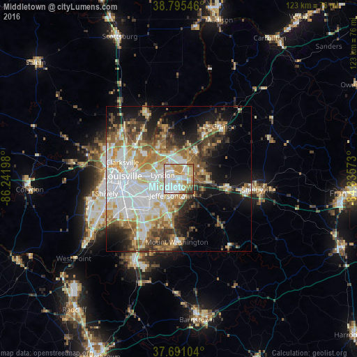
Analysis of Middletown night lights 2016
Square area 10x10 km:
 29.76%
90-99
27.04%80-89
14.97%70-79
14.8%60-69
7.82%50-59
2.21%40-49
2.38%30-39
1.02%20-29
0%10-19
0%0-9
0%Square area 50x50 km:
11.68%90-99
9.89%80-89
5.77%70-79
5.66%60-69
5.72%50-59
4.93%40-49
4.71%30-39
5.44%20-29
6.06%10-19
11.42%0-9
28.71%Clear (daylight) street map image can be seen on geolist.org.
Map coordinates:
38° 47' 43.7" North, 86° 14' 31.1" West
38° 14' 43.3" North, 85° 32' 19.9" West
37° 41' 27.7" North, 84° 50' 8.6" West
Some cities around Middletown sort by population:
• Jeffersontown
6.1 km =3.8 mi,  201°
201°
• Newburg
14.2 km =8.8 mi,  228°
228°
• Fern Creek
10.4 km =6.5 mi, 204°
• Saint Matthews
10.2 km =6.3 mi,  274°
274°
• Highview
13.6 km =8.5 mi,  213°
213°
• Lyndon
5.6 km =3.5 mi,  283°
283°
• Buechel
11.3 km =7 mi,  240°
240°
• Douglass Hills
1.5 km =0.9 mi, 235°
4300725 (p: 7,874)
Sources (retrieved 2019-11-25):
» Earth at Night: Flat Maps 2012, 2016