Buckner night lights from space
Night Light of Buckner (Kentucky) from space (United States) Src. Average luminocity for 10x10km area is 41.7415% and for 50x50km: 26.7705%.
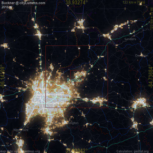
Analysis of Buckner night lights 2016
Square area 10x10 km:
 1.53%
1.53%90-99
4.42%80-89
6.97%70-79
6.12%60-69
7.31%50-59
4.25%40-49
17.18%30-39
12.41%20-29
15.65%10-19
17.69%0-9
6.46%Square area 50x50 km:
5.73%90-99
5.67%80-89
3.75%70-79
3.42%60-69
3.76%50-59
3.06%40-49
3.28%30-39
3.46%20-29
4.09%10-19
9.67%0-9
54.1%Clear (daylight) street map image can be seen on geolist.org.
Map coordinates:
38° 55' 57.9" North, 86° 8' 35.1" West
38° 23' 1.2" North, 85° 26' 23.9" West
37° 49' 49.5" North, 84° 44' 12.6" West
Some cities around Buckner sort by population:
• Jeffersontown
23.7 km =14.7 mi,  207°
207°
• Saint Matthews
23.8 km =14.8 mi,  232°
232°
• Lyndon
20 km =12.4 mi,  224°
224°
• La Grange
6 km =3.7 mi,  63°
63°
• Charlestown
21.5 km =13.4 mi,  291°
291°
• Middletown
17.6 km =10.9 mi, 209°
• Douglass Hills
19 km =11.8 mi, 211°
• Oak Park
24 km =14.9 mi,  248°
248°
4286037 (p: 5,837)
Sources (retrieved 2019-11-25):
» Earth at Night: Flat Maps 2012, 2016