Scottsboro night lights from space
Night Light of Scottsboro (Alabama) from space (United States) Src. Average luminocity for 10x10km area is 43.7028% and for 50x50km: 5.7957%.
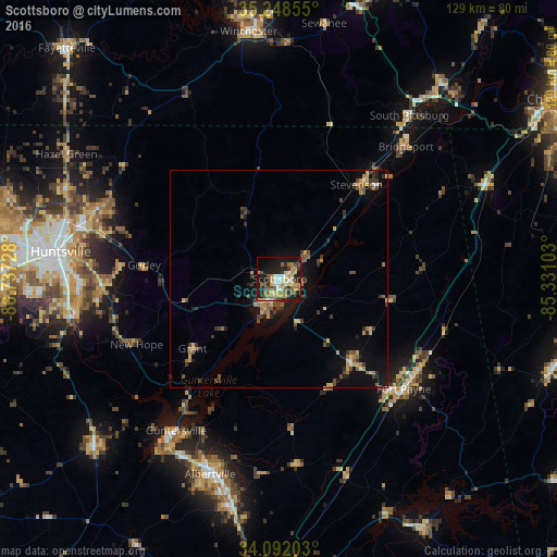
Analysis of Scottsboro night lights 2016
Square area 10x10 km:
 4.9%
4.9%90-99
5.59%80-89
8.39%70-79
8.92%60-69
8.04%50-59
5.94%40-49
4.2%30-39
5.94%20-29
11.89%10-19
28.15%0-9
8.04%Square area 50x50 km:
0.29%90-99
0.32%80-89
0.88%70-79
1.01%60-69
0.9%50-59
0.88%40-49
1.02%30-39
1.35%20-29
1.28%10-19
4.41%0-9
87.66%Clear (daylight) street map image can be seen on geolist.org.
Map coordinates:
35° 14' 54.8" North, 86° 44' 14.2" West
34° 40' 20.3" North, 86° 2' 2.9" West
34° 5' 31.3" North, 85° 19' 51.7" West
Some cities around Scottsboro sort by population:
• Huntsville
50.9 km =31.6 mi,  277°
277°
• Albertville
47.7 km =29.6 mi,  199°
199°
• Fort Payne
38.4 km =23.9 mi,  131°
131°
• Boaz
53.8 km =33.4 mi,  193°
193°
• Guntersville
42.3 km =26.3 mi,  214°
214°
• Meridianville
53 km =32.9 mi,  292°
292°
• Moores Mill
48.2 km =30 mi, 293°
• Rainsville
26.1 km =16.2 mi,  139°
139°
4088916 (p: 14,722)
Sources (retrieved 2019-11-25):
» Earth at Night: Flat Maps 2012, 2016