Moores Mill night lights from space
Night Light of Moores Mill (Alabama) from space (United States) Src. Average luminocity for 10x10km area is 40.2564% and for 50x50km: 26.1473%.
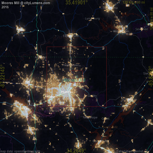
Analysis of Moores Mill night lights 2016
Square area 10x10 km:
 0.73%
0.73%90-99
0.73%80-89
5.86%70-79
9.34%60-69
9.34%50-59
8.97%40-49
14.29%30-39
7.33%20-29
12.82%10-19
25.27%0-9
5.31%Square area 50x50 km:
3.95%90-99
4.13%80-89
4.09%70-79
5.18%60-69
4.67%50-59
3.64%40-49
3.77%30-39
4.27%20-29
4.09%10-19
7.31%0-9
54.89%Clear (daylight) street map image can be seen on geolist.org.
Map coordinates:
35° 25' 8.4" North, 87° 13' 17.2" West
34° 50' 38.3" North, 86° 31' 6" West
34° 15' 53.6" North, 85° 48' 54.7" West
Some cities around Moores Mill sort by population:
• Huntsville
14.1 km =8.8 mi,  206°
206°
• Decatur
50.1 km =31.1 mi,  238°
238°
• Madison
26.5 km =16.5 mi,  232°
232°
• Athens
41.7 km =25.9 mi,  263°
263°
• Scottsboro
48.2 km =30 mi,  113°
113°
• Fayetteville
34.6 km =21.5 mi,  352°
352°
• Meridianville
5 km =3.1 mi,  279°
279°
• Harvest
21.3 km =13.2 mi,  273°
273°
4076982 (p: 5,682)
Sources (retrieved 2019-11-25):
» Earth at Night: Flat Maps 2012, 2016