Sayreville night lights from space
Night Light of Sayreville (New Jersey) from space (United States) Src. Average luminocity for 10x10km area is 82.0731% and for 50x50km: 68.0406%.
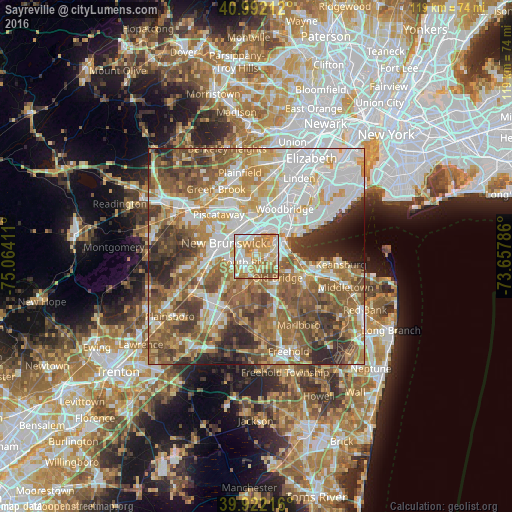

Analysis of Sayreville night lights 2016
Square area 10x10 km:
 15.99%
90-99
20.92%80-89
17.86%70-79
23.13%60-69
14.63%50-59
6.63%40-49
0.85%30-39
0%20-29
0%10-19
0%0-9
0%Square area 50x50 km:
15.98%90-99
14.1%80-89
8.72%70-79
9.95%60-69
12.39%50-59
13.7%40-49
8.35%30-39
7.32%20-29
6.4%10-19
2.22%0-9
0.85%Clear (daylight) street map image can be seen on geolist.org.
Map coordinates:
40° 59' 31.6" North, 75° 3' 50.8" West
40° 27' 33.4" North, 74° 21' 39.5" West
39° 55' 19.8" North, 73° 39' 28.3" West
Some cities around Sayreville sort by population:
• Piscataway
5.5 km =3.4 mi,  324°
324°
• East Brunswick
5.8 km =3.6 mi,  233°
233°
• Old Bridge
5 km =3.1 mi,  184°
184°
• South Old Bridge
5.7 km =3.5 mi,  174°
174°
• South River
2.5 km =1.6 mi,  236°
236°
• Highland Park
6.7 km =4.2 mi,  307°
307°
• South Amboy
6.3 km =3.9 mi,  70°
70°
• Madison Park
4.6 km =2.9 mi,  100°
100°
5104404 (p: 44,920)
Sources (retrieved 2019-11-25):
» Earth at Night: Flat Maps 2012, 2016