Big Lake night lights from space
Night Light of Big Lake (Minnesota) from space (United States) Src. Average luminocity for 10x10km area is 24.481% and for 50x50km: 9.5062%.
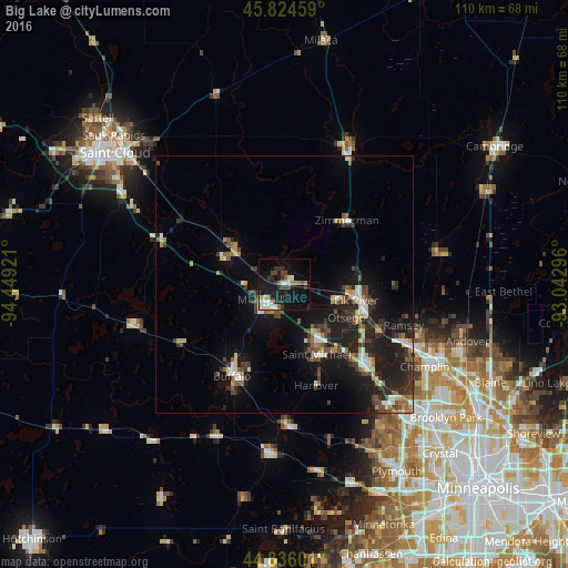
Analysis of Big Lake night lights 2016
Square area 10x10 km:
 3.97%
3.97%90-99
4.29%80-89
1.9%70-79
2.38%60-69
1.59%50-59
3.02%40-49
3.33%30-39
5.08%20-29
5.71%10-19
24.6%0-9
44.13%Square area 50x50 km:
1.07%90-99
1.15%80-89
0.83%70-79
0.92%60-69
0.94%50-59
1.35%40-49
1.65%30-39
2.03%20-29
3.35%10-19
9.18%0-9
77.54%Clear (daylight) street map image can be seen on geolist.org.
Map coordinates:
45° 49' 28.5" North, 94° 26' 57.2" West
45° 19' 56.9" North, 93° 44' 45.9" West
44° 50' 9.6" North, 93° 2' 34.7" West
Some cities around Big Lake sort by population:
• Elk River
14.3 km =8.9 mi,  102°
102°
• Saint Michael
15 km =9.3 mi,  155°
155°
• Buffalo
20.5 km =12.7 mi,  209°
209°
• Otsego
13.7 km =8.5 mi,  118°
118°
• Monticello
4.8 km =3 mi,  231°
231°
• Albertville
12.7 km =7.9 mi,  145°
145°
• Zimmerman
17.3 km =10.7 mi,  44°
44°
• Dayton
20.6 km =12.8 mi, 118°
5018285 (p: 10,368)
Sources (retrieved 2019-11-25):
» Earth at Night: Flat Maps 2012, 2016