Sallisaw night lights from space
Night Light of Sallisaw (Oklahoma) from space (United States) Src. Average luminocity for 10x10km area is 24.8864% and for 50x50km: 3.6833%.
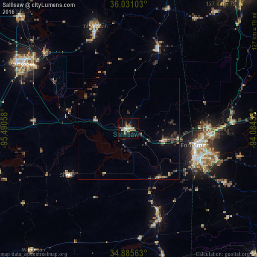
Analysis of Sallisaw night lights 2016
Square area 10x10 km:
 1.28%
1.28%90-99
2.93%80-89
6.23%70-79
2.93%60-69
4.58%50-59
3.3%40-49
1.28%30-39
2.38%20-29
4.58%10-19
25.82%0-9
44.69%Square area 50x50 km:
0.15%90-99
0.22%80-89
0.6%70-79
0.38%60-69
0.34%50-59
0.49%40-49
0.72%30-39
1.51%20-29
1.02%10-19
2.06%0-9
92.52%Clear (daylight) street map image can be seen on geolist.org.
Map coordinates:
36° 1' 51.7" North, 95° 29' 26.1" West
35° 27' 37.3" North, 94° 47' 14.8" West
34° 53' 8.3" North, 94° 5' 3.6" West
Some cities around Sallisaw sort by population:
• Fort Smith
36.2 km =22.5 mi,  103°
103°
• Muskogee
61.6 km =38.3 mi,  301°
301°
• Van Buren
39.9 km =24.8 mi,  93°
93°
• Tahlequah
53.2 km =33.1 mi,  341°
341°
• Greenwood
55.4 km =34.4 mi,  119°
119°
• Poteau
47.6 km =29.6 mi,  161°
161°
• Alma
51.3 km =31.9 mi, 87°
• Prairie Grove
71.3 km =44.3 mi,  36°
36°
4550374 (p: 8,596)
Sources (retrieved 2019-11-25):
» Earth at Night: Flat Maps 2012, 2016