Tahlequah night lights from space
Night Light of Tahlequah (Oklahoma) from space (United States) Src. Average luminocity for 10x10km area is 34.5769% and for 50x50km: 2.8614%.
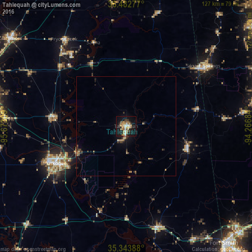
Analysis of Tahlequah night lights 2016
Square area 10x10 km:
 4.03%
4.03%90-99
4.03%80-89
7.14%70-79
6.78%60-69
3.48%50-59
4.21%40-49
3.85%30-39
4.95%20-29
4.03%10-19
38.46%0-9
19.05%Square area 50x50 km:
0.15%90-99
0.2%80-89
0.5%70-79
0.5%60-69
0.3%50-59
0.37%40-49
0.45%30-39
0.78%20-29
0.42%10-19
2.39%0-9
93.94%Clear (daylight) street map image can be seen on geolist.org.
Map coordinates:
36° 28' 58" North, 95° 40' 23.1" West
35° 54' 55.3" North, 94° 58' 11.9" West
35° 20' 38" North, 94° 16' 0.6" West
Some cities around Tahlequah sort by population:
• Muskogee
40.6 km =25.2 mi,  242°
242°
• Siloam Springs
49.1 km =30.5 mi,  51°
51°
• Coweta
61.4 km =38.2 mi,  273°
273°
• Pryor Creek
53.7 km =33.4 mi,  324°
324°
• Wagoner
36.3 km =22.6 mi,  277°
277°
• Pryor
53.7 km =33.4 mi, 324°
• Sallisaw
53.2 km =33.1 mi,  161°
161°
• Prairie Grove
59.1 km =36.7 mi,  83°
83°
4552707 (p: 16,598)
Sources (retrieved 2019-11-25):
» Earth at Night: Flat Maps 2012, 2016