Salem night lights from space
Night Light of Salem (Utah) from space (United States) Src. Average luminocity for 10x10km area is 25.0503% and for 50x50km: 8.3488%.
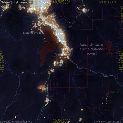
Analysis of Salem night lights 2016
Square area 10x10 km:
 0.32%
0.32%90-99
0.32%80-89
2.44%70-79
4.87%60-69
5.03%50-59
5.52%40-49
3.9%30-39
3.73%20-29
11.2%10-19
41.72%0-9
20.94%Square area 50x50 km:
1%90-99
1.23%80-89
1.12%70-79
1.3%60-69
1.1%50-59
1.15%40-49
1.04%30-39
1.43%20-29
2.65%10-19
5.54%0-9
82.45%Clear (daylight) street map image can be seen on geolist.org.
Map coordinates:
40° 35' 20.7" North, 112° 22' 36" West
40° 3' 10.8" North, 111° 40' 24.7" West
39° 30' 45.6" North, 110° 58' 13.5" West
Some cities around Salem sort by population:
• Provo
20.1 km =12.5 mi,  3°
3°
• Orem
27.2 km =16.9 mi,  356°
356°
• Spanish Fork
7.1 km =4.4 mi,  12°
12°
• Springville
13.6 km =8.5 mi,  23°
23°
• Payson
5.1 km =3.2 mi,  259°
259°
• Lindon
32.5 km =20.2 mi,  352°
352°
• Santaquin
12.8 km =8 mi,  227°
227°
• Mapleton
11.8 km =7.3 mi,  43°
43°
5555097 (p: 7,475)
Sources (retrieved 2019-11-25):
» Earth at Night: Flat Maps 2012, 2016