Mapleton night lights from space
Night Light of Mapleton (Utah) from space (United States) Src. Average luminocity for 10x10km area is 36.4107% and for 50x50km: 11.4671%.
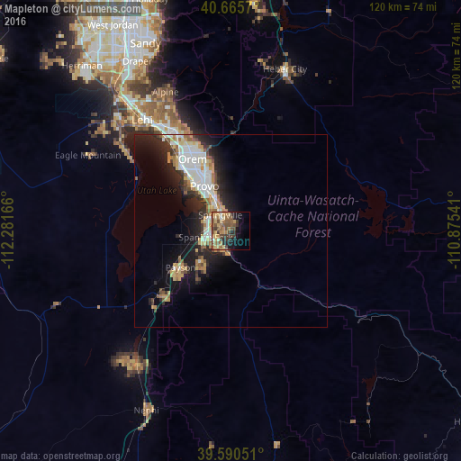
Analysis of Mapleton night lights 2016
Square area 10x10 km:
 0.97%
0.97%90-99
1.62%80-89
8.12%70-79
7.95%60-69
7.79%50-59
10.06%40-49
9.9%30-39
6.82%20-29
4.71%10-19
12.5%0-9
29.55%Square area 50x50 km:
1.85%90-99
2.15%80-89
1.55%70-79
1.66%60-69
1.28%50-59
1.38%40-49
1.2%30-39
1.53%20-29
3.6%10-19
6.82%0-9
76.99%Clear (daylight) street map image can be seen on geolist.org.
Map coordinates:
40° 39' 56.5" North, 112° 16' 54" West
40° 7' 48.8" North, 111° 34' 42.7" West
39° 35' 25.8" North, 110° 52' 31.5" West
Some cities around Mapleton sort by population:
• Provo
13.4 km =8.3 mi,  329°
329°
• Orem
21 km =13 mi, 331°
• Spanish Fork
6.7 km =4.2 mi,  255°
255°
• Springville
4.8 km =3 mi,  324°
324°
• Payson
16.2 km =10.1 mi,  233°
233°
• Lindon
26.6 km =16.5 mi, 332°
• Santaquin
24.6 km =15.3 mi, 225°
• Salem
11.8 km =7.3 mi,  223°
223°
5777915 (p: 9,232)
Sources (retrieved 2019-11-25):
» Earth at Night: Flat Maps 2012, 2016