Buffalo night lights from space
Night Light of Buffalo (Minnesota) from space (United States) Src. Average luminocity for 10x10km area is 19.7697% and for 50x50km: 8.4237%.
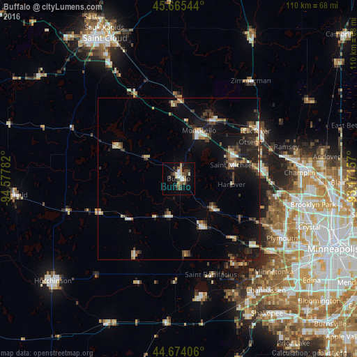
Analysis of Buffalo night lights 2016
Square area 10x10 km:
 3.03%
3.03%90-99
2.58%80-89
4.09%70-79
0%60-69
0.15%50-59
4.55%40-49
2.88%30-39
5.61%20-29
1.36%10-19
15.3%0-9
60.45%Square area 50x50 km:
0.78%90-99
1.06%80-89
1.05%70-79
0.76%60-69
0.72%50-59
1.25%40-49
1.26%30-39
1.62%20-29
2.3%10-19
7.06%0-9
82.16%Clear (daylight) street map image can be seen on geolist.org.
Map coordinates:
45° 39' 55.6" North, 94° 34' 40.2" West
45° 10' 18.9" North, 93° 52' 28.9" West
44° 40' 26.6" North, 93° 10' 17.7" West
Some cities around Buffalo sort by population:
• Saint Michael
17 km =10.6 mi,  75°
75°
• Otsego
24.9 km =15.5 mi,  62°
62°
• Monticello
16.1 km =10 mi,  23°
23°
• Rogers
25.3 km =15.7 mi,  85°
85°
• Big Lake
20.5 km =12.7 mi,  29°
29°
• Albertville
18.7 km =11.6 mi,  67°
67°
• Delano
15.9 km =9.9 mi,  155°
155°
• Corcoran
27 km =16.8 mi,  108°
108°
5019588 (p: 16,026)
Sources (retrieved 2019-11-25):
» Earth at Night: Flat Maps 2012, 2016