Plymouth night lights from space
Night Light of Plymouth (Indiana) from space (United States) Src. Average luminocity for 10x10km area is 28.3299% and for 50x50km: 2.9746%.
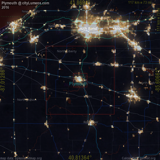
Analysis of Plymouth night lights 2016
Square area 10x10 km:
 3.4%
3.4%90-99
3.57%80-89
3.23%70-79
7.14%60-69
2.55%50-59
3.4%40-49
2.72%30-39
4.42%20-29
6.12%10-19
29.25%0-9
34.18%Square area 50x50 km:
0.15%90-99
0.29%80-89
0.34%70-79
0.51%60-69
0.43%50-59
0.57%40-49
0.4%30-39
0.5%20-29
0.76%10-19
1.53%0-9
94.53%Clear (daylight) street map image can be seen on geolist.org.
Map coordinates:
41° 52' 9.8" North, 87° 0' 46.3" West
41° 20' 37.2" North, 86° 18' 35" West
40° 48' 49.1" North, 85° 36' 23.8" West
Some cities around Plymouth sort by population:
• South Bend
38.1 km =23.7 mi,  7°
7°
• Mishawaka
37.6 km =23.4 mi,  19°
19°
• LaPorte
45.4 km =28.2 mi,  310°
310°
• La Porte
44.7 km =27.8 mi, 311°
• Warsaw
39.9 km =24.8 mi,  107°
107°
• Nappanee
28 km =17.4 mi,  66°
66°
• Rochester
32 km =19.9 mi,  165°
165°
• Notre Dame
40.1 km =24.9 mi, 8°
4924970 (p: 10,035)
Sources (retrieved 2019-11-25):
» Earth at Night: Flat Maps 2012, 2016