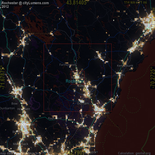
Rochester night lights from space
Night Light of Rochester (New Hampshire) from space (United States) Src. Average luminocity for 10x10km area is 29.4758% and for 50x50km: 7.3268%.

Analysis of Rochester night lights 2016
Square area 10x10 km:
 1.82%
1.82%90-99
3.94%80-89
2.73%70-79
3.48%60-69
4.39%50-59
7.42%40-49
8.48%30-39
2.27%20-29
3.64%10-19
38.94%0-9
22.88%Square area 50x50 km:
0.69%90-99
1.23%80-89
0.83%70-79
0.65%60-69
0.96%50-59
1%40-49
1.16%30-39
0.88%20-29
1.77%10-19
7.27%0-9
83.55%Clear (daylight) street map image can be seen on geolist.org.
Map coordinates:
43° 48' 50.6" North, 71° 40' 43.5" West
43° 18' 16.3" North, 70° 58' 32.2" West
42° 47' 26.5" North, 70° 16' 21" West
Some cities around Rochester sort by population:
• Dover
14.5 km =9 mi,  145°
145°
• Sanford
22.1 km =13.7 mi,  47°
47°
• Somersworth
10.1 km =6.3 mi,  118°
118°
• Durham
19.4 km =12.1 mi,  168°
168°
• Barrington
10.8 km =6.7 mi,  212°
212°
• South Berwick
15.5 km =9.6 mi, 120°
• Eliot
22 km =13.7 mi,  139°
139°
• Lebanon
14.2 km =8.8 mi, 45°
5091872 (p: 30,038)
Sources (retrieved 2019-11-25):
» Earth at Night: Flat Maps 2012, 2016