Robertsdale night lights from space
Night Light of Robertsdale (Alabama) from space (United States) Src. Average luminocity for 10x10km area is 32.6978% and for 50x50km: 16.6104%.
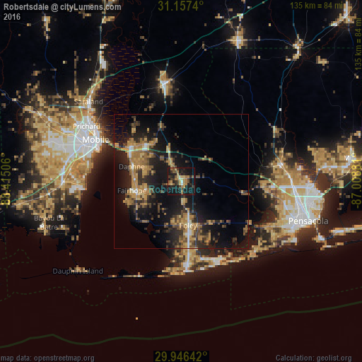
Analysis of Robertsdale night lights 2016
Square area 10x10 km:
 1.1%
1.1%90-99
1.28%80-89
6.23%70-79
4.95%60-69
9.16%50-59
4.4%40-49
4.03%30-39
6.04%20-29
10.44%10-19
41.76%0-9
10.62%Square area 50x50 km:
0.58%90-99
0.8%80-89
2.22%70-79
3.42%60-69
4.05%50-59
2.1%40-49
2.96%30-39
3.71%20-29
5.55%10-19
15.77%0-9
58.84%Clear (daylight) street map image can be seen on geolist.org.
Map coordinates:
31° 9' 26.6" North, 88° 24' 54.2" West
30° 33' 13.7" North, 87° 42' 42.9" West
29° 56' 47.1" North, 87° 0' 31.7" West
Some cities around Robertsdale sort by population:
• Mobile
35.3 km =21.9 mi,  296°
296°
• Cantonment
36.1 km =22.4 mi,  80°
80°
• Daphne
19.2 km =11.9 mi,  286°
286°
• Fairhope
18.6 km =11.6 mi,  259°
259°
• Foley
16.6 km =10.3 mi,  170°
170°
• Gulf Shores
34.2 km =21.3 mi,  178°
178°
• Spanish Fort
23.7 km =14.7 mi, 304°
• Orange Beach
31.7 km =19.7 mi,  155°
155°
4086363 (p: 5,894)
Sources (retrieved 2019-11-25):
» Earth at Night: Flat Maps 2012, 2016