Foley night lights from space
Night Light of Foley (Alabama) from space (United States) Src. Average luminocity for 10x10km area is 54.2308% and for 50x50km: 19.3416%.
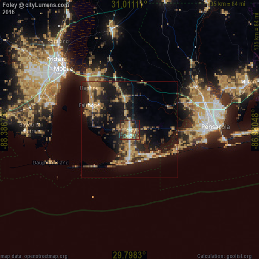
Analysis of Foley night lights 2016
Square area 10x10 km:
 4.76%
4.76%90-99
6.78%80-89
10.26%70-79
8.79%60-69
13.92%50-59
8.97%40-49
13.55%30-39
9.16%20-29
15.57%10-19
8.06%0-9
0.18%Square area 50x50 km:
1.01%90-99
1.17%80-89
3.12%70-79
3.62%60-69
4.12%50-59
2.28%40-49
3.49%30-39
4.18%20-29
6.22%10-19
17.7%0-9
53.09%Clear (daylight) street map image can be seen on geolist.org.
Map coordinates:
31° 0' 40" North, 88° 23' 12.2" West
30° 24' 23.7" North, 87° 41' 1" West
29° 47' 53.9" North, 86° 58' 49.7" West
Some cities around Foley sort by population:
• Daphne
30.4 km =18.9 mi,  316°
316°
• Bellview
35.9 km =22.3 mi,  80°
80°
• Fairhope
24.7 km =15.3 mi,  301°
301°
• Myrtle Grove
36.1 km =22.4 mi,  87°
87°
• Gulf Shores
17.9 km =11.1 mi,  185°
185°
• Spanish Fort
37.2 km =23.1 mi, 323°
• Robertsdale
16.6 km =10.3 mi,  350°
350°
• Orange Beach
16.3 km =10.1 mi,  139°
139°
4062644 (p: 17,218)
Sources (retrieved 2019-11-25):
» Earth at Night: Flat Maps 2012, 2016