Gulf Shores night lights from space
Night Light of Gulf Shores (Alabama) from space (United States) Src. Average luminocity for 10x10km area is 35.2797% and for 50x50km: 11.6926%.
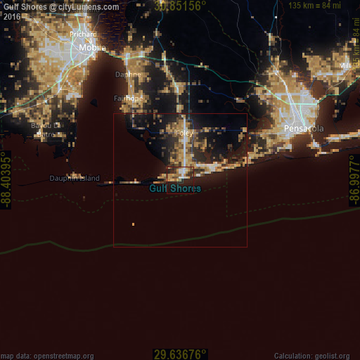
Analysis of Gulf Shores night lights 2016
Square area 10x10 km:
 3.85%
3.85%90-99
4.72%80-89
6.64%70-79
6.12%60-69
5.59%50-59
2.27%40-49
7.34%30-39
3.32%20-29
11.71%10-19
24.48%0-9
23.95%Square area 50x50 km:
0.79%90-99
0.89%80-89
2.06%70-79
1.77%60-69
2.04%50-59
1.44%40-49
2.3%30-39
2.73%20-29
3.64%10-19
9.73%0-9
72.6%Clear (daylight) street map image can be seen on geolist.org.
Map coordinates:
30° 51' 5.6" North, 88° 24' 14.2" West
30° 14' 45.7" North, 87° 42' 3" West
29° 38' 12.3" North, 86° 59' 51.7" West
Some cities around Gulf Shores sort by population:
• Daphne
44.2 km =27.5 mi,  333°
333°
• Bellview
44.1 km =27.4 mi,  57°
57°
• Fairhope
36.4 km =22.6 mi, 327°
• Foley
17.9 km =11.1 mi,  5°
5°
• Myrtle Grove
42.5 km =26.4 mi, 62°
• Warrington
43.7 km =27.2 mi,  69°
69°
• Robertsdale
34.2 km =21.3 mi,  358°
358°
• Orange Beach
13.3 km =8.3 mi, 66°
4065552 (p: 11,131)
Sources (retrieved 2019-11-25):
» Earth at Night: Flat Maps 2012, 2016